About Aqua Map USA: Marine & Lake
An app to satisfy all your Fishing and Boating's needs, developed with the help of expert boaters. Download the best up-to-date Nautical Charts to safely enjoy the new boating season. With the Aqua Map Master transform...
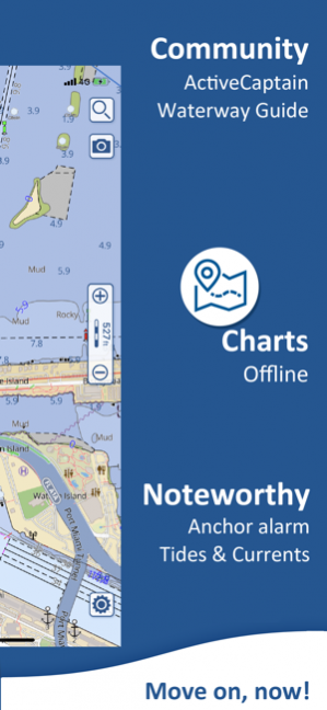
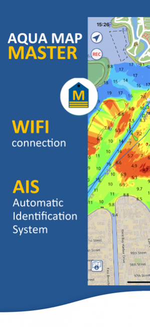
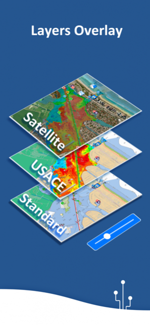
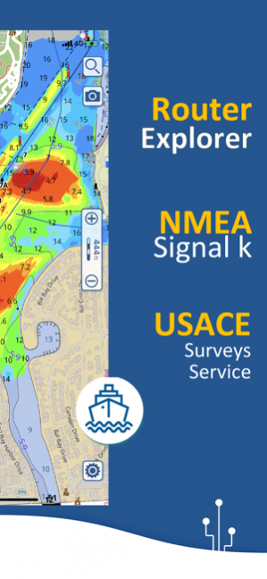
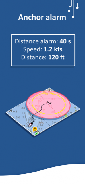
An app to satisfy all your Fishing and Boating's needs, developed with the help of expert boaters. Download the best up-to-date Nautical Charts to safely enjoy the new boating season. With the Aqua Map Master transform your device in a real ChartPlotter. ►► Features: • Optimised for both iPhone and iPad • Download the maps on the device for offline usage • Plan and navigate your ROUTE with real-time information on next waypoint • Anchor alarm with advanced configuration • Tides & Currents prediction and simulation • Overlay the USACE surveys on top of your charts • Share and load tracks, markers and routes (KMZ and GPX) • ActiveCaptain & Waterway Guide community integration • Connect your NMEA devices through WiFi • Display AIS info from external devices with automatic collision detection • Powerful search with advanced settings • Use the bird view to better see what in front of you • Overlay the Satellite images on your map • Fully support iOS 13 Dark/Light aspect • Measure distances on the map • Check all the bridges, hazards and best fuel prices along your route • Query map objects at your finger tip • Works perfectly in iPad multi-screen mode • Optimized battery usage ► MAPS Aqua Map lets you download - No additional purchases!!! - the best US Nautical charts (from NOAA), the US Major Rivers (from USACE) with depth contours, buoys, lights, etc. plus more than 12000 lakes maps with contours. A complete land chart with roads, tracks, and important places is also included. You can download the maps at home within your device and then use them on the boat without any Internet connection. ► ROUTES and WAYPOINTS Plan your trip, insert and edit waypoints. Navigate your route and monitor distance, time (ETA) and direction toward your next waypoint or your final destination. ► ANCHOR ALARM This function will check in realtime your GPS position against your anchor position previously defined. An acoustic and visual alarm will run as soon as your GPS position is out of the preferred range. ► TIDES & CURRENTS You can calculate the prediction for more than 6800 stations in the US & Canada. You can also have a simulation of the T&C trend on the map. ► LOADING and SHARING You can share your favorite's markers on Facebook or send an email with your last daily track. Not only, you can also load any KML, KMZ, GPX (also zipped) found in internet or received from your friends. ► ActiveCaptain Join the community of more than 100.000 boaters who write reviews, update data and provide up to date hazard information. Read and contribute reviews and rating about marinas, shared local boating knowledge, anchorage and hazards ► Waterway Guide Marinas, hazards, anchorages, bridges, free docks and much more to cover the entire US coastline. ► Aqua Map Master With this subscription you will access a set of advanced functions that will transform your device in a real ChartPlotter (.. and more). Connect your NMEA (and SignalK) devices through the WiFi and use their data for all the App functions (eg Anchor Alarm), download and display the last USACE surveys, consult the Route Explorer with bridges, hazards and best fuel prices calculation, display the AIS targets on the map with automatic collision detection. ► TYPE OF PURCHASES - Unlimited: you can download and update your charts forever. - Subscription: it is a one year auto-renewable subscription, it will automatically renews unless auto-renew is turned off at least 24-hours before the end of the current period. Subscriptions may be managed by the user and auto-renewal may be turned off by going to the user's Account Settings after purchase. Terms of Service: http://www.globalaquamaps.com/Acknowledge.html Privacy Policy: http://www.gec-it.com/GEC-privacy.pdf ———— The continuous GPS usage, also in background, can drastically reduce the battery life.
27 Apr 2020 Version 20.15 • Small improvements for the more complete and easier to use Marine App
Previous Versions
Here you can find the changelog of Aqua Map USA: Marine & Lake since it was posted on our website on 2016-09-27 16:09:53.
The latest version is 20.15 and it was updated on 2024-03-27 20:01:59. See below the changes in each version.
Aqua Map USA: Marine & Lake version 20.15
Updated At: 2020-04-27
Changes: 27 Apr 2020 Version 20.15
• Small improvements for the more complete and easier to use Marine App
Aqua Map USA: Marine & Lake version 20.15
Updated At: 2020-04-27
Changes: Apr 27, 2020 Version 20.15
• Small improvements for the more complete and easier to use Marine App
Aqua Map USA: Marine & Lake version 20.14
Updated At: 2020-03-31
Changes: 31 mar 2020 Version 20.14
• Improved GPS Track recording algorithm
• Improved GPX file import
• Solved a problem with "Disable Auto-lock" setting
Aqua Map USA: Marine & Lake version 20.14
Updated At: 2020-03-31
Changes: Mar 31, 2020 Version 20.14
• Improved GPS Track recording algorithm
• Improved GPX file import
• Solved a problem with "Disable Auto-lock" setting
Aqua Map USA: Marine & Lake version 20.12
Updated At: 2020-03-20
Changes: Mar 20, 2020 Version 20.12
• Small improvements for the most complete and easy to use marine app.
Aqua Map USA: Marine & Lake version 20.11
Updated At: 2020-03-06
Changes: Mar 6, 2020 Version 20.11
• Improved Help
• Small improvements for the most complete and easy to use marine app.
Aqua Map USA: Marine & Lake version 20.7
Updated At: 2020-01-21
Changes: Jan 21, 2020 Version 20.7
• Now the Perspective view is automatically disabled when in Anchor mode
• Solved an issue in Wind True calculation under special conditions
• Improved USACE drawing in some areas
Aqua Map USA: Marine & Lake version 6.1
Updated At: 2013-09-20
Aqua Map USA: Marine & Lake version 20.14
Updated At: 1970-01-01
Changes: 31 de mar. de 2020 Version 20.14
• Improved GPS Track recording algorithm
• Improved GPX file import
• Solved a problem with "Disable Auto-lock" setting
Disclaimer
Official App Store Link
We do not host Aqua Map USA: Marine & Lake on our servers. We did not scan it for viruses, adware, spyware or other type of malware. This app is hosted by Apple and passed their terms and conditions to be listed there. We recommend caution when installing it.
The App Store link for Aqua Map USA: Marine & Lake is provided to you by apps112.com without any warranties, representations or guarantees of any kind, so access it at your own risk.
If you have questions regarding this particular app contact the publisher directly. For questions about the functionalities of apps112.com contact us.